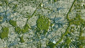
Chandigarh has geo-mapped approximately 13,000 properties under the centre-backed NAKSHA project. The move marks a significant step towards modernising urban land records and improving property governance in the Union Territory.
The exercise is part of a nationwide initiative to create a digital, accurate repository of urban property records through geospatial mapping and survey-based verification.
“The project is intended to improve transparency, reduce disputes over property ownership and support more efficient urban planning.”
-said officials
Also Read: Kochi GIS Mapping: Authorities to Address Stormwater Drainage Network Under AMRUT Scheme
NAKSHA Project Advances Digital Property Mapping in Chandigarh
According to officials, Chandigarh is among the selected cities participating in the National Geospatial Knowledge-based Land Survey of Urban Habitations (NAKSHA) programme.
The project combines modern surveying techniques with digital mapping to create updated records of residential and commercial properties.
The geo-mapping exercise has covered approximately 13,000 properties so far. Authorities are using the data to build a comprehensive digital database that can be integrated with existing land and municipal records.
The initiative is expected to support faster verification of property details and help streamline administrative processes linked to taxation, ownership records and urban development.
Also Read: Genesys International Secures ₹2.8 Crore GIS Mapping Order From National Mission for Clean Ganga
Transparency and Urban Governance: Top Priorities
“The project will strengthen property record management and improve the accuracy of urban land data. The availability of GIS-based property information is expected to assist government departments in planning infrastructure projects & civic services in a better way.”
-said officials
The NAKSHA programme forms part of the broader push towards digital governance and land record modernisation across India. Accurate property mapping is increasingly being viewed as a critical component of smart city planning, urban infrastructure development and citizen-centric governance.
With thousands of properties already mapped, Chandigarh’s progress under the project is expected to help create a more reliable, technology-driven property management framework.

Samarjit Kaur is a journalist and communications professional covering technology & emerging digital trends. With a focus on clarity and context, she reports on developments shaping industries and governance. When not reporting, she chooses to plug-in and relax on her playlists and plan her next bucket-list trips!